Micro-temperature seeing survey was conducted at the Astronomical Observatory Vidojevica (Wee-dough-ye-wee-tsa) in southern Serbia in December 2015 / January 2016. Winter is not the ideal season for this type of measurements as the telescopes are predominantly used in warmer part of the year, mostly because of the cloud cover. Micro-temperature probe with sensors 1m apart was mounted on the location chosen for the 1.4m telescope dome at the mountain top 1185 m above sea level, on a pole 7m high.
Clear and overcast calm nights

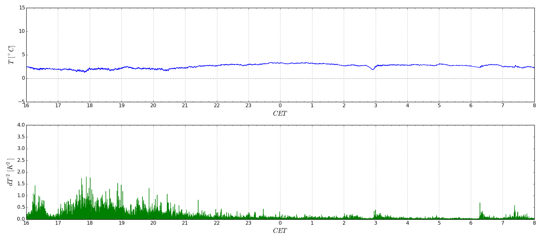
The first diagram above represents typical air turbulence data for a relatively calm overcast night. It can be observed that turbulences take a few hours after the sunset (5 PM) to gradually calm down. Were it not for the thin cloud cover, the graph would suggest that optimal seeng conditions lasted between 22 PM and sunrise at 6 AM.

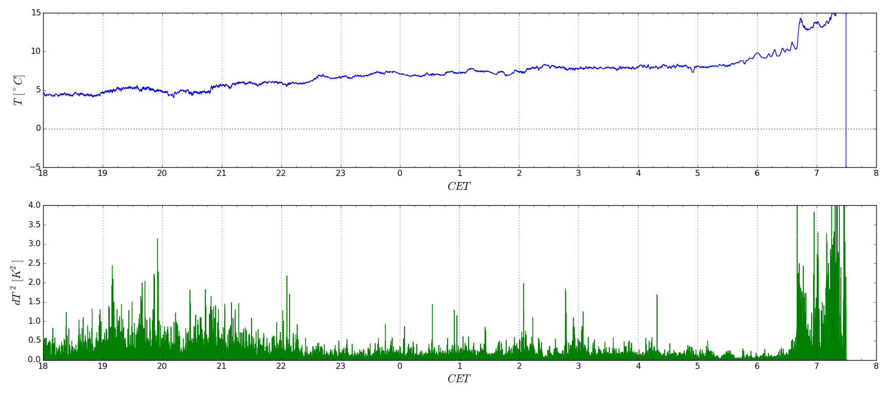
The second diagram is an example of a clear sky night with sunny weather on the preceeding and following day. We can see that turbulences are generally higher during night hours when the surrounding terrain has been heated by the sun. Thus an ideal observing nights would be the ones with low winds and clear sky, fallowing a very cloudy day. Unfortunately not many nights in a typical year fit such description.
Windy nights

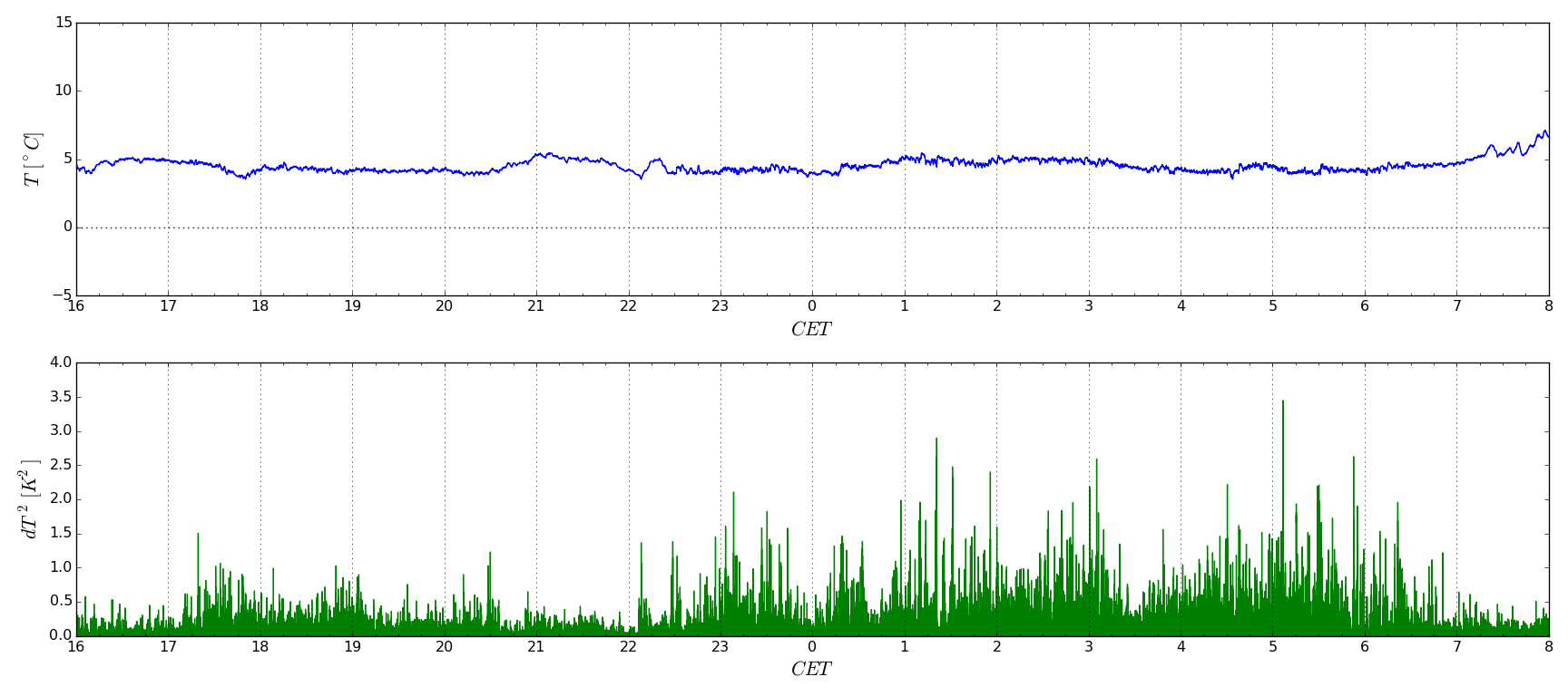
Data in the third diagram was captured during one of the overcast nights with strong winds. It can be observed that despite terrain temperature was not significantly hightened during light hours, movements of large air masses are never laminar. Winds bring strong turbulences so they not only make imaging sky with telescopes hard because of induced vibrations, but also spoil seeing.
Turbulence theory initiated by Kolmogorov in the middle of XX century implies that turbulent flow in feee air begins as a relatively large swirl that splits into progressively smaller ones as the time passes. Original swirl forms when wind blows over rough terrain which slows the air flow in the lower layers with respect to the higher ones, or over heated ground which heats lower layers or air and pushes them upwards; in both cases air forms "rollers" that disturb the laminar flow. The largest swirls that Earth atmosphere is able to form are a few kilometers in diameter, while the smallest ones are as small as a few mm. The process of "swirl splitting" in effect pushes kinetic energy of original laminar air flow into regions of higher and higher Rayleygh's numbers until further splitting requires such degree of energy losses that directional organized movement at yet smaller scales becomes impossible. Smallest swirls then quickly vanish due to viscous friction. Therefore taken as a whole, the process dissipates coherent kientic energy of the original laminar flow of air into uncorrelated heat vibrations of air mollecules.
Physical properties of the atmosphere are such that large swirls can travel quite long distances along the path of the wind that induced them before they eventually dissipate. Weather conditions that produced the above diagram were such that wind was blowing from north, passing over a nearby town some 20 km away. Cities are probably the worst type of terrain one can imagine with respect to its tendency to induce air turbulences - they consist of very rough and dense "ubran canyons" made of concrete that tend to accumulate heat during the day. Thus both mechanisms of producing initial "air rollers" i.e. inducing both vertical velocity gradients and strong vertical drafts come into play. This is the reason that ideal locations for astronomical observations are high mountain peaks surrounded by large unforested flats or ocean. Telescopes are placed on that side of the mountain that faces the prevailing winds so that there is very little time and place for turbulnet swirls to form before the moving air reaches the domes.
Meteo station re-check

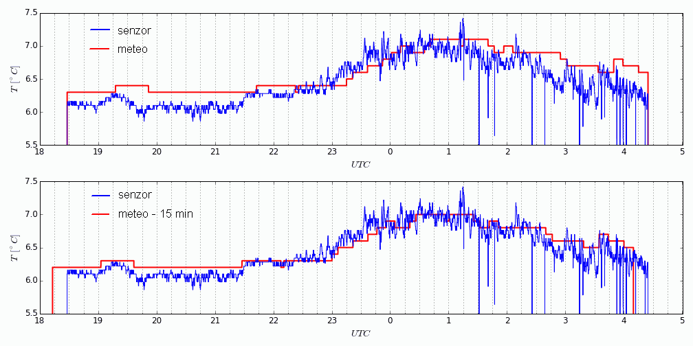
The last diagram illustrates a curious fact about local professional meteorological station that we spotted when correlating its reading to readouts from the seeing probe. When comaparing the two data streams side-to-side, we noted that there is a significant delay of approximately 20 minutes in meteo station data with respect to UTC. We could not explain the reason; we believe that there is probably some kind of digital low-pass filtering performed inside the station computer so it exchanges real-time reporting for higher data precision. This is however not mentioned in its user manual and we wonder whether such undocumented quirks influence weather forecasts relying on data collected from similar automated meteo stations.

